Subsurface Locating and Mapping


Ground Penetrating Radar

The GS8000 GPR is the most flexible and efficient real-time workflow and technology to scan, locate, and map the subsurface for objects and features such as utilities, structure, voids, sinkholes, burial remnants, footers, tanks, drain fields, and more.
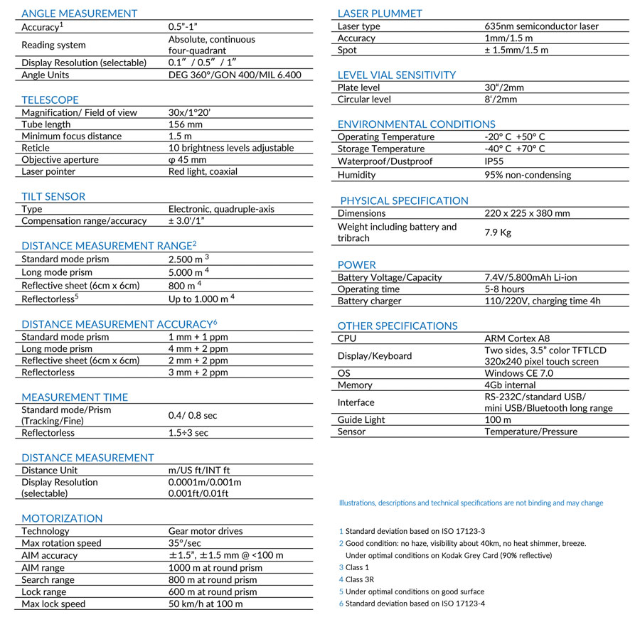
  • Scan and create images of the underground in 2D and 3D as you walk.
  • Digitize on-site findings on the map and send to CAD/GIS.
  • Easily share and access your data from anywhere, anytime.

GS8000 SPECS


Price:   Call or Email for a Quote!
Questions? Contact Tyler Bristow | 757.647.7016 | tyler@centerlinemapping.com

GS8000 Package Options


GS8000 Lite
- consisting of: GS8000 Lite push cart, integrated GPR sensor (Stepped Frequency: 40-3440 MHz), tablet holder with sunshade cover, power supply, cables, Wi-Fi module, basic tools & accessories, documentation. GS8 Lite License (5 years included). This package provides software and hardware for locating buried objects using traditional A-scan and B-scan functionality.

GS8000 Lite Upgrade to Pro
- consisting of: GS8000 Lite push cart, integrated GPR sensor (Stepped Frequency: 40-3440 MHz), tablet holder with sunshade cover, power supply, cables, Wi-Fi module, basic tools & accessories, documentation. Upgrade from GS8 Lite to Pro License (5 years included). This package provides software and hardware for locating and mapping buried objects using traditional A-scan and B-scan functionality and NEW Freepath software. Users can bring their own GNSS receivers to the GPR such as the Stonex S900+ base and/or single rover. Consult with our team on your exact GNSS to determine if it will integrate with the GPR.

GS8000 Pro
- consisting of: GS8000 Pro push cart, integrated GPR sensor (Stepped Frequency: 40-3440 MHz), GNSS rover, fiber carbon pole, tripod, tablet holder with sunshade cover, power supply, cables, Wi-Fi module, basic tools & accessories, documentation, hard transportation case. GS8 Pro License (5 years included). This package provides software and hardware for locating and mapping buried objects using traditional A-scan and B-scan functionality and new Freepath software, along with a rover and correction service.


Contact Us!


Have a question about something? Get in touch!

Email us: tyler@centerlinemapping.com
Give us a call: 757-647-7016